
-
- Author, Santiago Vanegas
- Author's title, BBC News World
The African Union, the organization that brings together all African states, joined a campaign on Monday to stop using Mercator projection for the Mapamundis.
The campaign, called Correct The Map (“Correct the map”), seeks to prevent governments, organizations, schools and companies from representing the most small African continent than it really is.
“It might seem that it is only a map, but it really is not,” the Vice President of the African Union commission, Selma Malika Haddadi told the Agency.
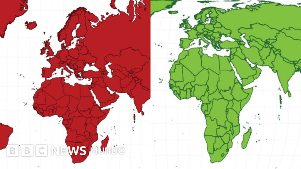
The projection of Mercator, invented in the sixteenth century by the European cartographer Gerardus Mercator, shows larger the territories closest to the poles, such as North America and Europe, with respect to those that are located near the line of Ecuador, such as Africa and South America.
This was the solution that Mercator found a mathematical problem: to represent a spherical planet on a flat surface.
The campaign Correct The Map promotes adopting a projection that is known as Equal Earthwhich most accurately reflects the size of the continents.
The Mapamundis that follow the projection of Mercator are those that use applications such as Google Maps by default, and are possibly the ones that have most configured our mental image of the planet.
“For more than 450 years, we have based our understanding of Africa and the world on a map that is wrong,” reads the website of Correct The Map.
The movement defends that distortion in the size of the continents on the map is a problem of “power and perception.”
The executive director of Africa No Filterone of the organizations behind the campaign, has described the projection of Mercator as “the greatest disinformation campaign.”


A mathematical problem
It is mathematically impossible to exactly project a curved surface like that of the earth on a flat, such as a paper or a screen.
Therefore, all the plans of the earth's surface are necessarily distorted. Depending on the technique used to create them, the size, shape and location of the continents changes.
The cartographers for centuries have been aware of that problem and solve it according to the use they want to give to the map.
Mercator made his famous projection, which became the most popular in history, thinking of a specific need: navigation.
And he got his Mapamundi, a navigator knew in which direction he should go according to the compass to get from one point to another.
The problem of Mercator's projection is that it exaggerates the size of the countries as they move away from the line of Ecuador.
This occurs because it is a cylindrical projection, which presents the meridians as equidistant parallel lines.
Meridians are actually lines found in the poles; That is, the distance between them is decreasing as they move away from Ecuador.
The distortion that characterizes the projection of Mercator means that, for example, Greenland and Africa are seen of similar size, when in reality the continent is about 14 times larger.
Brazil, meanwhile, is five times larger than Alaska, although on the map they seem of similar dimensions.

Image source, Bardocz Peter via Getty Images

Subscribe here To our new newsletter to receive every Friday a selection of our best content of the week.
And remember that you can receive notifications in our app. Download the latest version and act.